Blog

10 May

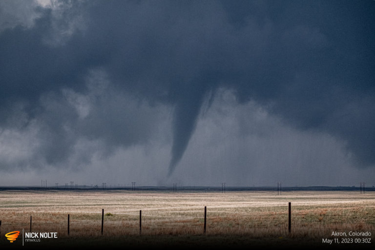
May 10, 2023 – Akron, Colorado

May 10th featured a rare 10% tornado risk in Northeast Colorado. When you have strong easterlies pumping moist air into the foothills you chase Colorado. While a trough was digging into the Four Corners, a lee cyclone was forecast to sit in Eastern Colorado with a warm front stretching into Northwest Kansas. This actually presented two decent targets for tornadoes as the Kansas play wasn’t something to discount.

Read more
19 Apr

April 19, 2023 – Kiron, Iowa

April 19th featured an enhanced risk encompassing the quad state area between Nebraska, Iowa, Kansas, and Missouri. A low pressure that developed in Kansas was forecast to move eastward to the Missouri River by sunset by the shortwave trough that was ejecting into the Plains. This would draw low 60°F dewpoints into Iowa and that looked like a good place to be to me.

Read more
31 Mar

March 31, 2023 – Keota, Iowa Tornado

March 31st was shaping up to be a significant weather event in the mid-Mississippi Valley as forecast models were showing a low deepening to 988 along with a 100+ kt mid level jet. It all just depended where it setup. SPC had outlined the area beginning on the Day 6 outlook on March 26th. They upgraded it to 30% the following day, then went moderate on the Day 2 and initial Day 1 that was upgraded to dual high risk areas at the 1630z update.

Read more